Benutzer-Werkzeuge
Dies ist eine alte Version des Dokuments!
Neu in MIKE+ 2022, Update 1
⯇ Zurück zu MIKE+
Unsere Vision ist, den Wasserkreislauf ganzheitlich abzubilden. Neben urbanen Funktionen, wie dem Abwassernetz und der Wasserversorgung, bietet MIKE+ auch die Möglichkeiten für die GIS-basierte Simulation von Langzeitserien, Echtzeitsteuerung, Oberflächenabfluss sowie Stoff- und Sedimenttransport. Zusätzlich bieten wir die Möglichkeit der Löschfallsimulation.
Mit jedem neuen Release gibt es in der Siedlungswasserwirtschaft und der Benutzeroberfläche zahlreiche Neuerungen. Folgende Seite listet die wichtigsten Verbesserungen und Neuheiten von MIKE+ 2022.1 und weiter unten von MIKE+ 2022 (ohne Anspruch auf Vollständigkeit).
Angaben zu älteren Versionen finden Sie in der MIKE+ Versionsgeschichte.
Allgemeine Änderungen
Versionsmanager (Model Versions Comparison)
Der Versionsmanager hilft dabei, das Modell in MIKE+ aktuell zu halten, in dem verschiedene Versionen miteinander verglichen werden. Somit ermöglicht diese neue Werkzeug eine Unterstützung, um die Übersicht zu bewahren und ein gezieltes Aktualisieren durchzuführen. Der Manger findet sich unter Werkzeuge (Tools) > Model Versions Comparison and Update.
In einem ersten Schritt werden zwei verschiedene Versionen (eines Modells) miteinander verglichen, unter Angabe eines Hauptmodells. ("Master version")


Mit Hilfe der Übersicht zu den Änderungen erkennt man auf den ersten Blick die Abweichungen und Unterschiede der ausgewählten Versionen.

Im letzten Schritt kann man dann entscheiden, wie mit diesen Abweichungen umgegangen werden soll.

Wasserversorgung
Neuorganisation von Zonen
Bisher basierte die Zonenverteilung auf Auswahllisten, weshalb eine Aktualisierung schwierig und etwas umständlich war. Ab Version MIKE+ 2022.1 kann man sich jetzt aussuchen, ob die Zonenorgansiation auf Auswahllisten oder den Netzinformationen basiert. Somit kann man die Zoneninformation in die Editoren importieren und direkt verwenden.

Auch in der Bedarfsstatistik kann man nun den Zonenbedarf einsehen.

Neu: EPANET MSX (Multi-Species eXtension)
Dieses neue Spezialwerkzeug ist eine Erweiterung zur Berechnung der Wasserqualität. Damit können auch verschiedene, aufeinander reagierende chemische Stoffe abgebildet werden. Beispielsweise kann damit der Bakterieller Zuwachs bei gleichzeitiger Behandlung mit Chlor modelliert werden.
Neu in MIKE+ 2022
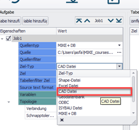
Neu: Export von Karten- und Ergebnisdaten nach CAD
Ein Export von Karten- und Ergebnisdaten aus MIKE+ in die Formate .dwg und .dfx ist nun möglich. Sie können Kartendaten oder Längenschnitte per Mausklick exportieren.
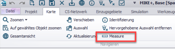
Neu: Messwerkzeug
Mit dem Update auf MIKE+ 2022 wurde auf populären Kundenwunsch hin ein Messwerkzeug eingeführt.
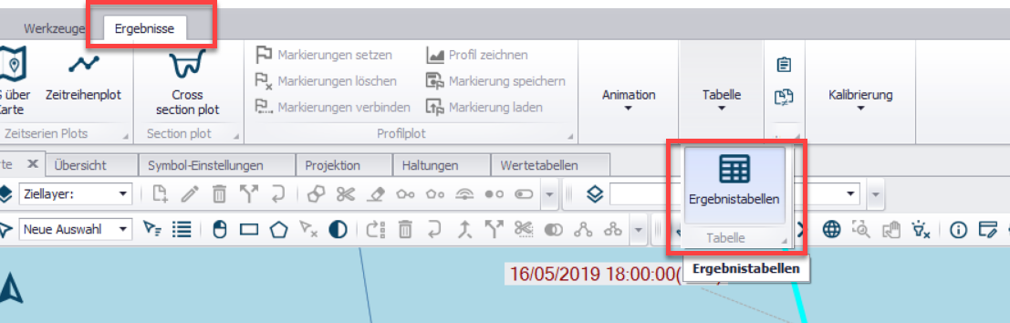
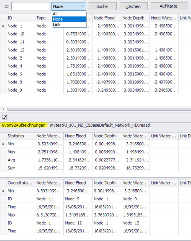
Neu: Ergebnistabelle und Statistiken
In der Siedlungsentwässerung haben Sie die Möglichkeit, statistische Kennzahlen, wie Minima, Maxima oder Durchschnitte, sowie akkumulierte Werte zu berechnen. Sie können diese für Einzugsgebiete und Netzwerkresultate berechnen.
Zur besseren Ergebnisübersicht haben Sie mit dem release von MIKE+ 2022 die Möglichkeit, eine Tabelle zu erstellen. Es vereint Daten aus Ihren Modelldaten und den (statistischen) Resultaten. Diese Tabelle können Sie kopieren und sofort in Excel oder anderen Kalkulationsprogrammen verwenden.
Neu: Import - Zusammenfügen mehrerer Datenbanken
Beim Import von Daten in Ihr MIKE+ Projekt können Sie durch die Neuerungen im Automap-Tool mehrere Datenbanken automatisch zusammenführen.
Mit Hilfe des Import-/ Exporttools können Sie Datenbanken ab MIKE+ 2022 über die Asset-ID Daten aus verschiedenen Datenbanken Updaten. Zuvor war das nur über die MUID möglich.
Das Import-/ Exporttool ermöglicht es Ihnen mit dem Update, Punkte aus CAD-Blöcken zu importieren.
Neu: Modell- und Ergebnisbericht
Durch den Modell- und Ergebnisbericht haben Sie die Möglichkeit, aus den Daten der *.squlite, wie Asset-ID oder Beschreibung, und der *.res1d und anhängenden statistischen Berechnungen, eine Tabelle zu erstellen.
Neu: Vereinfachung Fließpfadanalyse
Sowohl in der Wasserversorgung, als auch in der Siedlungsentwässerung wurde die Fließpfadanalyse vereinfacht. Sie haben nun leichter die Möglichkeit, für Sie irrelevante Informationen bei der Analyse auszublenden.
Die Verbesserungen in der Ergebnisdarstellung führen dazu, dass Sie eine bessere Übersicht über Ihre Resultate erlangen, noch bevor Sie einen Output generieren. Zusätzlich wurden einige Bugs ausgemärzt.
Wasserversorgung
- Online Analyse: MIKE+ Daten können zu einem SCADA Kontrollsystem hinzugefügt werden. Das Werkzeug ist für die Analysemöglichkeiten unseres verbesserten Waternet Advisors ausgelegt. Die Daten werden über ein Online-Analyse Tool eingefügt.
- Pumpen- und Ventiloptimierung: Das neue Analysetool zur Pumpen- und Ventiloptimierung erlaubt Ihnen, den idealen Betriebszustand zu ermitteln. Durch diese Neuerung können in weiterer Folge Einsparungs- oder Energieoptimierungspotentiale ermittelt werden.
- Eine weitere Neuerung in MIKE+ 2022 gibt Ihnen die Möglichkeit, den Energieverbrauch, Kostenanalysen oder die CO2 Äquivalente der Betriebszustände zu analysieren.
Siedlungsentwässerung
Vergleichen von Ergebnissen
Sie haben ein Stand-Alone Werkzeug zur Verfügung, das es Ihnen ermöglicht, Varianten eines Modells direkt mit einander zu vergleichen. Über die Befehlszeile finden Sie das Tool Result Verification:
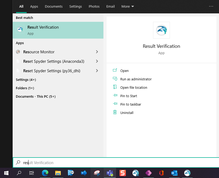
Sie können das Werkzeug für Variantenstudien einsetzen oder alte Modelle mit Ihren Berechnungen in MIKE+ 2022 vergleichen. Eine weitere Einsatzmöglichkeit bietet sich mit dem Vergleich von verschiedenen Netzdaten nach einem Update an. Das Werkzeug informiert Sie automatisch über grobe Differenzen zwischen Ihren Varianten.
Eine Visualisierung und ein Vergleich der Ergebnisse von alten Modellen und neuen Modellen ist durch ein neues Asset Management System möglich.

2D Überflutungen
- Kopplung von Advektions-Dispersions Berechnung 1D mit 2D
- MIKE ZERO Launch: Simulationen sind nun über MIKE ZERO Launch möglich und erlauben Ihnen so, neben einer laufenden Simulation den Model Manager frei zu halten. Somit können Sie den Model Manager trotz laufender Simulation auf einem anderen Endgerät verwenden.
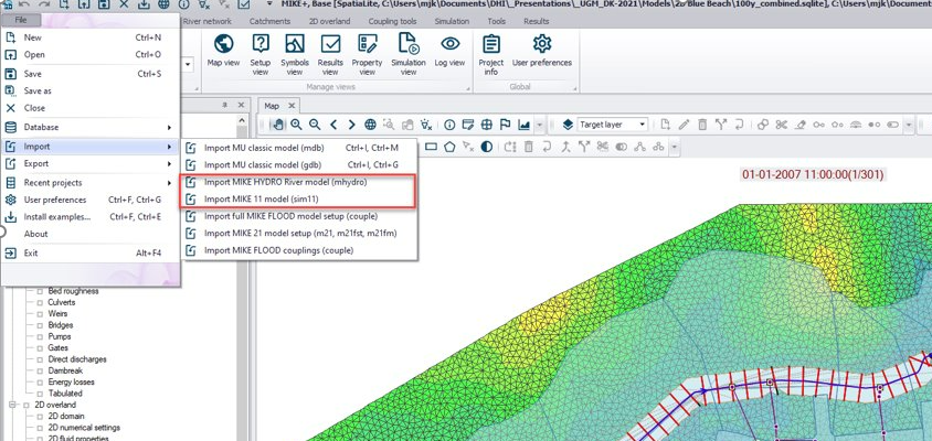
- Fließgewässer Import: Sie können nun Daten aus MIKE HYDRO River, MIKE 11 und Oracle Spatial importieren.
MIKE+ 2022 Release Notes
New Features
| Modul/Typ | Fehler/Neues Feature | Status |
|---|---|---|
| General | SWMM model networks can now be coupeld to a 2D overland model. In this version, couplings to the 2D model are only available with nodes, and coupling of water quality components is not supported | New Feature |
| General | Map data from MIKE+ can now be exported to CAD files (.dwg and .dxf formats), using the import and export tool. | New Feature |
| General | Longitudiunal profile plots can be now exported to CAD files (.dwg format). | New Feature |
| General | From the "Import and Export" tool, it is now possible to import data from an Oracle spatial database- | New Feature |
| General | Connecting to a WMS server to display background layers now allow connecting through a proxy server | New Feature |
| General | A new "Measure" tool is avialable in the ribbon bar, in the Map tab. It allows measuring distances on the map along segments or plylines, as well as polygons' areas. | New Feature |
| General | The "Export map" button has been added to the ribbon, in the Map-tab. It can be used to save the map layout to an image file. | New Feature |
| General | The "Import and Export" tool can be executed from a command line, reading the import/export configuration from a configuration file. | New Feature |
| General | A new "Automap" button has been added to the "Import and Export" tool. When importing data from MIKE+ projects to an other MIKE+ project, this button will create all sections corresponding to all relevant tables in the MIKE+ database for the active working mode and will populate them with the proper assignments. Duplicates will be renamed. | New Feature |
| General | In the "Import and Export" tool, a new job property called "Source text format" has been added. This option applies when converting input strings (texts) to numbers, and controls how the decimal seperator is identified. | New Feature |
| General | A new function called DoubleFromString has been added to the Expression editor, to convert input string (text) data to numerical values and controlling the format of the decimal seperator in the input text. It can be e.g. be used in the "Field calculator" or the "Import and Export" tool. | New Feature |
| General | The date and time of results shown in the "Property and result explorer is now synchronised with the date and time of results shown on the map. | New Feature |
| General | It is now possible to export simulation files and run simulations from a command line also for Water Distribution and SWMM model types. | New Feature |
| General | The tool "Clone and repair database", available in the File menue, may be used with damaged and corrupt databases. It will create a new database but without the damaged tables, which can be then populated again manually. | New Feature |
| General | A default unit system can now be selected from the "User preferences dialog, to choose between SI and US unit systems. It will especially control in which unit system the results are shown, when no model database is opened. | New Feature |
| General | In the "Model and result report" tool "Joins" can now merge data from model tables and results in a common table of the report. A new "Time step" option also allows adding a column to the join table, with results from a selected time step. | New Feature |
| General | In "Rivers, collection systems and overland flows" mode, closing MIKE+ while a simulation is running will offer an option to continue the simulation outside of the MIKE+ application. This option can be used to release the license module of the user interface while running a simulation. | New Feature |
| Collection System and Rivers | A new "Statistics" content type can be selected for catchments and network result files. This type of result file stores max / min / average values and time of max/ min value, as well as accumulated values for the relevant result items, computed throughout the simulation. These statistics are computed during the simulation and therefore do not depend on a storing frequency of the results. | New Feature |
| Collection System | A new "Results differences" tool is available in the "Results" tab in the ribbon. This tool is designed for comparing results from different variants of hydraulic network simulations, and report any significant difference of result. This may e. g. be used when comparing results from a former version of a model and results from a new version updated with the latest information from an asset management system. The tool allows you to quickly identify locations where results differences are observed, and visualise and vompare results at these locations. It is not necessary to have a model database opened for using the tool. | New Feature |
| Collection System | An "initial level" can now be specified in the weir's and orifices' properties, to control the elevation of structures controlled by control rules at the start of the simulation. | New Feature |
| Rivers | Several new types of structures are now available for river networks: Pumps, Bridge structures, Dambrakes, Tabulated structures, and user-defined Energy losses. | New Feature |
| Rivers | River models previously created with MIKE HYDRO River or MIKE 11 can now be imported automatically into MIKE+, from the File\ Import menu. Please note that the import is limited to the river functionalities currently supported in MIKE+ (mainly the river and catchments definitions as well as structures and boundary conditions), whereas some functionalities remain unsupported for now in MIKE+ and are ignored during the import (e. g. storages, multiple zone resistance and time-varying resistance factors, variables, side structures, etc.). Before importing a river model, make sure that all expected river functionalities are available in MIKE+ and check for possible warnings in the Log after the import. | New Feature |
| 2D overland | Improved performance for 2D overland applications using GPU acceleration: Tuning of timings and numerous small tweaks, OpenMP parallelization for pre-processing of infrastructure, Pre-processing of boundary conditions (initialization), Optimised data transfer on 2D flood statistics results; In addition a new dynamic list approach is used together with optimised gradient calculation for forcing calculations. | Improvement |
| 2D overland | Coupling of Advection- Dispersion components is now possible also when coupling the 1D network to a MIKE 21 FM or MIKE 3 FM file. | New Feature |
| SWMM | The "Topology Repair" tool is now also available for SWMM model networks. | New Feature |
| Water Distribution | A new "optimisation" special analysis has been added. It is used to optimise pumps and valves' behavior to meet e. g. target water depth, pressure or flow in the network. | New Feature |
| Water Distribution | A new "Online analysis" special analysis has been added. It is used to map the model data from MIKE+ to SCADA system's data, especially for use in Water Distribution Online. | New Feature |
| Water Distribution | The "Pipe Criticality" special analysis has been renamed §Network vulnerability", and now also reports criteria related to nodes. | New Feature |
| Water Distribution | In interactive fire flow analyses, a new "Free discharge hydrant" method has been added, which computes both hydrant discharge and residual pressure for a free discharge hydrant. | New Feature |
| Water Distribution | Extra result items "Tap pressure" and "Demand allocations pressure" are now saved during simulations. | New Feature |
| Water Distribution | Extra result items related to pumps are saved during simulations: efficiency, energy costs and energy. These items are saved only when the simulation is performed using the EPANET 2.2 engine version. | New Feature |
| MIKE 1D Engine | Added static volume output to Pump Emergency Storage calculations (TT59012). | New Feature |
Fixed issues
| General | User-defined columns were not exported, when a feature layer was exported to a shape file. |
| General | An unexpected error "Unable to open database file. x64 is True" was obtained when running a simulation from a MIKE+ project saved on a network location (other than the local machine). |
| General | Colours on extra result maps could be inconsistent with the defined colour palette, when multiple result layers (from multiple result files) were added to the same map. |
| General | In the Profile plot properties, it was not allowerd to apply negative values to control the minimum and maximum values along the right Y-axis. |
| General | An unexpected error sometimes occured when loading the symbology for a shape file from a file. |
| General | RDI additional result items were not saved to result files. |
| General | An unexpected error about a non-existing source was provided in the "Import and Export" tool when trying to export a result layer to e. g. shape file. |
| General | When loading a .dfs0 time series in the list of result files, the "Time period to load" was ignored and the entire time series was always loaded. |
| General | Values imported from the "import and Export" tool were wrongly altered in some cases, when the decimal separator in the source file was a comma. |
| General | Shape files exported from a model with a coordinate system with length unit in feet were defined with inconsistent coordinates and units. |
| General | Various errors preventing from showing background maps from some WMS servers have been corrected. |
| General | An error preventing from displaying a Google Map or Open Street Map background layer for some map projections, when the projection's false origin is defined exactly at the border of the valid region. |
| General | When exporting a feature layer to a shape file, the feature name was always appended as a suffix. It is now appended only when multiple shape files are exported for the same feature layer. |
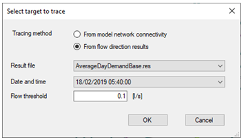
| General | Flow tracing from results was wrong when the flow in the first pipe was smaller than the threshold value. |
| General | When activating the option "Show columns in active tab" from the context menu of overview grids, several columns from the active tab were not shown. |
| General | An unexpected error occurred when using time series with a non-equidistant time axis in the "Plots and statistics" editor. |
| Collection System | in the Initial conditions editor, data in the table of local values were deleted when the set of the initial conditions was renamed. |
| Collection System | Various improvements and corrections to the validation of data from the VS network and catchments have been made. |
| Collection System | Attributes "Description" and "Asset Name" failed to import from MIKE URBAN classic, for the catchments table. |
| Collection System | An unexpected error was sometimes onbtained when computing the Distributed weights for grid distributed rainfall boundary conditions. |
| Collection System | Attributes "NetTypeNo" and "Element_S" were missing in the list of domains when applying the Field calculator in "Pipes and canals" editor. |
| Collection System | MIKE+ did not allow defining aboundary condition in a soakaway node. |
| Collection System | An unexpected error "Found non-noded intersection" was sometimes obtained when trying to merge catchments with the Network simplification tool. |
| Collection System | Wrong validation errors were reported in the Expression editor when using a sensor with type "Action Active Time", because it was wrongly considering it as a double value. |
| Rivers | Rivers imported from shape files were always given a chainage length of 100 m, regardless of the actual length of the imported lines. |
| Rivers | An unexpected error occurred when exporting cross sections to shape file. |
| Rivers | From the "Measurement stations" editor, using the arrow button to pick a river location from the map did not pick the chainage location along the river from the clicked location. |
| 2D overland | MIKE+ did not provide the expected warning message when the generation of the mesh failed. |
| 2D overland | The "Apply" option for 2D boundary conditions was ignored, making the boundary conditions always active. |
| 2D overland | Various errors occurring when importing a MIKE 21 and/or MIKE FLOOD file into MIKE+ have been fixed. |
| 2D overland | Coordinates of the 2D domain's extent were wrongly converted between feet and meters during import from MIKE URBAN classic. |
| 2D overland | Attributes from 2D overland editors could not be selected as target in the "Interpolation and assignment" tool. |
| 2D overland | The coupling tools "Create couplings" and "Edit location" were wrongly disabled when coupling the 2D overland module to a MIKE HYDRO River file. |
| 2D overland | MIKE+ failed saving the "Roughness value" and "Infiltrated volume" result items in 2D result filed when selected. |
| 2D overland | It is now possible to filter the list in the "1D-2D couplings" editor by coupling type. |
| 2D overland | When several 2D boundary conditions had the same code value (i. e. defining a discontinuous boundary condition), only the first part was displayed on the map. |
| 2D overland | Simulations failed when including a1D-2D coupling to a soakaway node, due to an unexpected error claiming the node type was incorrect. |
| 2D overland | The list "Couple to" was missing in the "1D-2D couplings" editor, when computing to an existing MIKE 21 file instead of the 2D overland module. |
| SWMM | "Asset ID" could not be added as X-Axis below profile plots, for some SWMM network features. |
| SWMM | Date and times from time series relative time, were wrongly interpreted in the simulation if they were typed in with values higher than 1 day. |
| SWMM | The "Default time step for new rows" in the "Time series" editor did not work properly. |
| SWMM | The layer type "Catchments" was missing from the list of target layers, in the map's toolbar. |
| Water Distribution | An unexpected error was sometimes obtained when loading some .dat files in the "Measurement stations" editor, due to a non-recognized format. |
| Water Distribution | The import of EPANET .inp files sometimes failed with missing error descriptions. |
| Water Distribution | Start date and End date could not be specified for special days in patterns. |
| Water Distribution | The relative viscosity was wrongly given a unit of m |
| Water Distribution | Sustainability Analysis sometimes failed to report empty or full tanks. |
| Water Distribution | Option "Report raw results" did not work. |
| Water Distribution | With EPANET 2.2 engine, wrong demand value was considered inthe fire flow analysis with the method "Pressure for flow" and in the flushing analysis. |
| Water Distribution | An unexpected validation error about the input string's length was returned when selecting "Link Flow" (absolute)" as result item in the "Plots and statistics" editor. |
| Water Distribution | Demand statistics was not taking into account the value of a demand multiplier if entered in the Multiple demands editor. |
| Water Distribution | Im Editor Pumpen war bei drehzahlgeregelten Pumpen (mit Sollniveau im Pumpensumpf) die minimale Kennlinie ausgegraut und konnte nur im Tabellenbereich bearbeitet werden. |
| MIKE 1D engine | Added support for decimal entry of UHM curve number values. |
| MIKE 1D engine | Fixed error causing failure of LTS job list. |
| MIKE 1D engine | Fixed scripting error in which res1D file not released by MIKE 1D controller. |
| MIKE 1D engine | Fixed error in display of collection system slope in html summary. |
| MIKE 1D engine | Corrected data type expected for sensor type "ActionActiveTime". |
| MIKE 1D engine | Added more informative error message to users attempting to obtain LTS results for "weirs out of system" for setups with internal weirs only. |
| MIKE 1D engine | Added support for "Close" and "Open" actions for valves in RTC setups. |
| MIKE 1D engine | Assed onfprmative error message for setups with duplicate branch definitins. |
| MIKE 1D engine | Added informative error message for setups with time series missing continuously increasing time series values. |
| MIKE 1D engine | Corrected unhandled exception occurring when importing setup from MIKE HYDRO River. |
| MIKE 1D engine | Corrected saving error occurring when results saving period is user-defined. |
| MIKE 1D engine | Disabeld unit conversion to standard units before input to control module. |
| Couplings engine | Fixed error in which couplings engine did not close properly after am error during initialisation. |
| MIKE 1D engine | Made change to order of calculations to enable "SaveFullRunningDischarge" feature. |
| Couplings engine | Fixed formatting error in html summary for coupled simulations. |
| Couplings engine | Added informative error message when node coupled to 2D model located outside 2D domain. |