Benutzer-Werkzeuge
Neu in MIKE+ 2024
Auf dieser Seite beschreiben wir die wichtigsten Verbesserungen und Neuheiten von MIKE+ 2024 (ohne Anspruch auf Vollständigkeit).
Angaben zu älteren Versionen finden Sie in der MIKE+ Versionsgeschichte.
Allgemeine Änderungen
Darstellung von BIM-Daten im Lageplan
Die Verwendung von BIM-Daten ( (Building Information Modeling) wird immer populärer, nicht zuletzt durch Initiativen auf EU-Ebene. MIKE+ erlaubt jetzt die Darstellung von IFC-Dateien im Lageplan. Je nach Erfordernis kann in künftigen Versionen von MIKE+ auch die Import/Export-Schnittstelle entsprechend erweitert werden.
MIKE+ 2024 Model Manager User Guide (Seite 39)
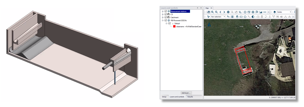
Links zu sehen ist das RB Roosweid, welches zum AV Höfe in der Schweiz gehört. Das 3D-Modell wurde erstellt von der Basler & Hofmann AG. Rechts ist das Becken im Lageplan von MIKE+ als Hintergrundlayer eingeblendet.
Längsschnitt mit mehr Gestaltungsmöglichkeiten
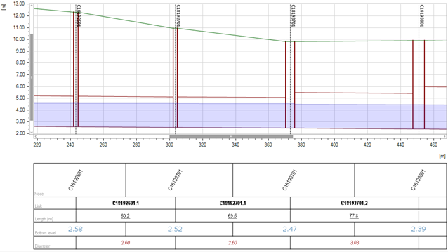
Das Beschriftungsband lässt sich besser anpassen:
- Reihenfolge der Zeilen
- Schriftart und Schriftfarbe
- Textausrichtung
Der Export eines geschriebenen Längenschnitts in Form einer Textdatei ist nun auch für Kanalnetze und Fließgewässer möglich. Bisher konnten lediglich Wasserversorgungnetze exportiert werden.
Beschleunigtes Versionsmanagement
Versionsanagement hilft, Simulationsmodelle regelmäßig nachzuführen und Änderungen im Anlagenbestand aus dem Netzinformationssystem gezielt zu übernehmen, ohne modellspezifische Anpassungen zunichte zu machen.
Die Performance des Versionsmanagements ist insgesamt verbessert worden.
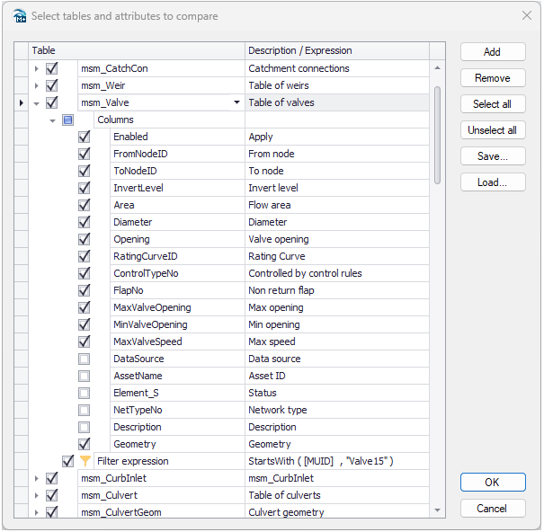
Darüber hinaus konnten bisher lediglich die abzugleichenden Tabellen festgelegt werden. Nun lässt sich der Abgleich in zweierlei Hinsicht näher definieren, sodass Konflikte treffsicherer ausgewiesen werden, und deren Behebung rascher erfolgen kann:
- Erstens lässt sich der Vergleich auf bestimmte Attribute einschränken, statt alle Attribute zu vergleichen.
- Zweitens reduziert ein Filter den Vergleich auf bestimmte Zeilen, sodass uninteressante Datensätze aus dem Netzinformationssystem keinen Einfluss mehr haben, oder der Vergleich gebietsweise erfolgen kann (sofern die Gebiete durch ein entsprechende Attribut gekennzeichnet sind).
Neues Werkzeug zur Erstellung von Höhenzonen
- Entwickelt für Niederschlags-Abfluss-Modelle mit der RDI-Methode und Berücksichtigung der Schneeschmelze
- Teilt das Einzugsgebiet unter Verwendung von DEM-Daten automatisch in bestimmte Höhenzonen auf
MIKE+ 2024 Model Manager User Guide (Seite 239) • Chapter 9.5.4 Create elevation zones from DEM tool
MIKE+ Siedlungsentwässerung
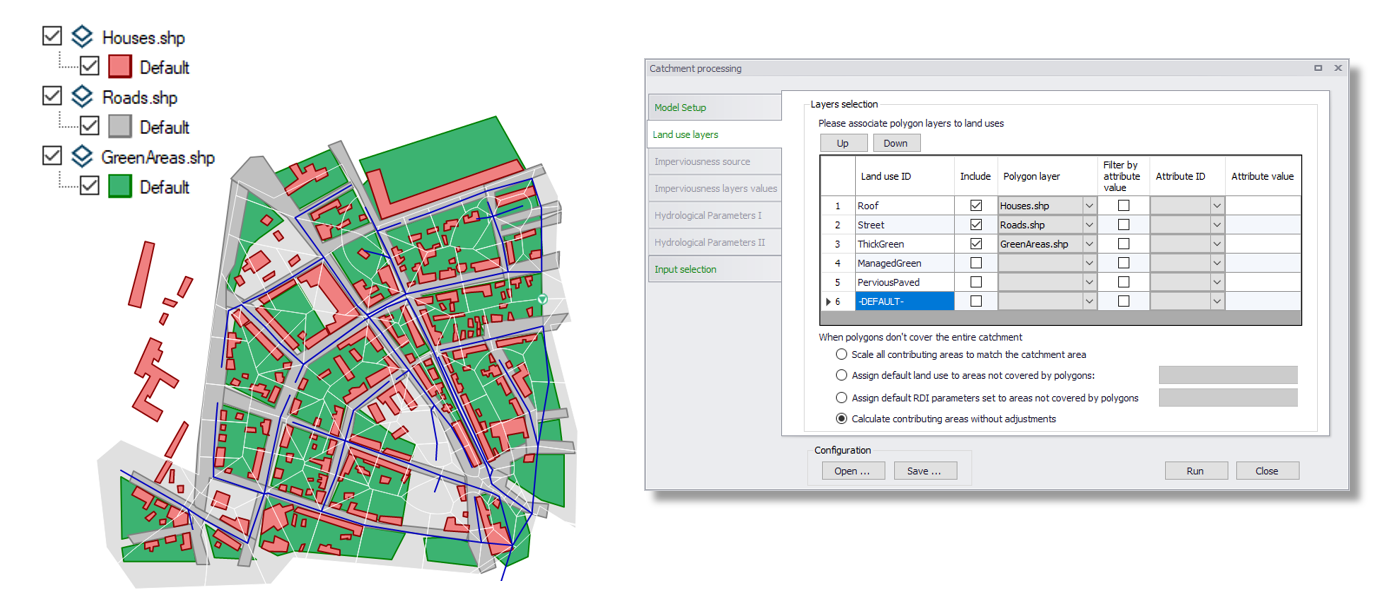
Berechnung der Landnutzung je Einzugsgebiet aus GIS-Daten
Die Vorgehensweise wird im On-Demand Webinar Getting the most out of hydrological models von 25:44 bis 39:26 erklärt.
- Bei der Verarbeitung von Einzugsgebieten werden jetzt die Anteile eines Einzugsgebiets, die von Hintergrund-Polygonlayern bedeckt sind, abgeleitet und die Landnutzungen entsprechend zugewiesen.
- Bei Verwendung von RDI akzeptiert die Landnutzungstabelle im Einzugsgebietseditor nun auch RDI-Parametersätze als Eingabe.
MIKE+ 2024 Collection System User Guide (Seite 148) • Chapter 4.2.7 Land uses
MIKE+ 2024 Model Manager User Guide (Seite 232) • Catchment processing - Land use layers
Kopplung mit dem Grundwasser
Neu in 2024 ist, dass die Parameter zur Kopplung mit MIKE SHE direkt in MIKE+ konfiguriert werden können (die Simulation selbst wird aus MIKE SHE heraus gestartet).
Dies ist vor allem interessant, um zu untersuchen, wie sich Versickerungsmaßnahmen der blau-grünen Infrastruktur auf den Bodenwasserhaushalt und auf umliegende Gebäude auswirken, oder wie eine Kanalsanierung den Fremdwassereintrag unterbindet und den Grundwasserspiegel ansteigen lässt.
MIKE+ Wasserversorgung
Neue Funktion Zonenwasserbilanz
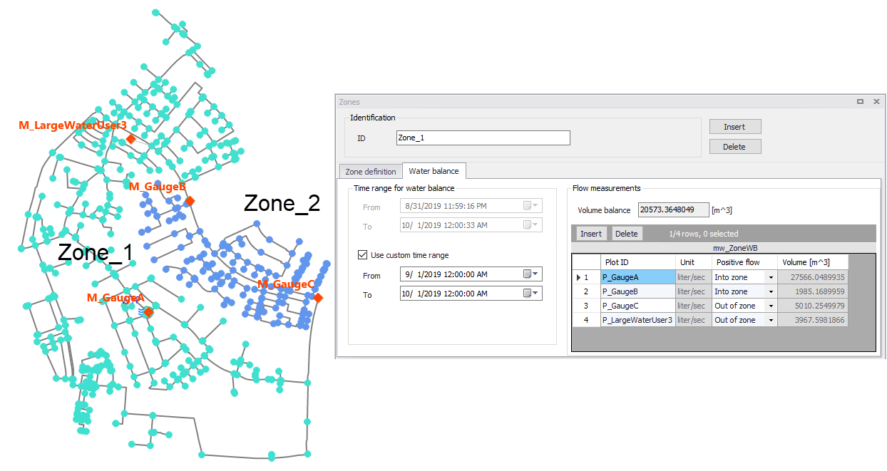
- Berechnung der Wasserbilanz für definierte Zonen mit gemessenen Zeitreihen
- Die neue Funktion "Berechnung des Bedarfs und der Leckagen in den Zonen" schätzt den durchschnittlichen Bedarf und die Leckagen
- Verteilte Bedarfe": Erzeugt Bedarfswerte in Knoten oder Rohren für Simulationen
- Erstellen von Zeitmustern' erzeugt tägliche oder wöchentliche Bedarfswerte auf der Grundlage gemessener Daten und spart so Zeit für manuelle Aufgaben.
MIKE+ 2024 Water Distribution User Guide (Seite 81) • Water balance
MIKE+ 2024 Water Distribution User Guide (Seite 88) • Chapter 4.1.5 Compute zone demand and leakage tool
MIKE+ 2024 Water Distribution User Guide (Seite 90) • Chapter 4.1.6 Create time patterns tool
Drehzahlgeregelte Pumpen basierend auf einem Durchfluss
- Ergänzt die bestehenden Druck- und Wasserstandsregelungsarten
- Konstanter oder zeitabhängiger Sollwert
MIKE+ 2024 Water Distribution User Guide (Seite 50) • Control type
MIKE+ 2D Überflutungen
Neues Werkzeug Hochwasserpolygone
- Wandelt rohe Hochwasser-Ergebnisdateien in klassifizierte Ergebnispolygone um
- Arbeitet mit verschiedenen Ergebnistypen, einschließlich Hochwassergefahr und Strömungsgeschwindigkeit
- Enthält Filter zur Vereinfachung der Karte und spart dem Benutzer Zeit im Vergleich zur manuellen GIS-Verarbeitung.
MIKE+ 2024 Model Manager User Guide (Seite 495) • Chapter 21 Create Flood Maps Tool
Direkte Unterstützung von TIFF-Dateien für 2D-Interpolation
- Erspart die Konvertierung von TIFF-Dateien in das dfs2-Format für die Zuordnung von Höhenangaben zu 2D-Netzen.
MIKE+ 2024 Release Notes
New Features
| Modul/Typ | Neues Feature |
|---|---|
| General | The table below the profile plot has been revisited. Data are now presented in a true table, and the style of its content (e.g. font and rotation) can be customised. The table can now also show the values from user-defined columns created in the links or nodes editors. |
| General | Zooming on the profile plot has been improved. The new default zoom option is to zoom to a rectangle. While zooming to a rectangle, drawing a line along the X or Y-axis zooms only on this axis, leaving the other axis unchanged. Zooming in/out using the mouse wheel zooms at the position of the cursor. |
| General | BIM files (*.ifc) can now be displayed on the map. |
| General | The symbology editor now allows to hide polygons' contours, by setting the outline thickness to 0. |
| General | The symbology editor offers new color ramps. |
| General | A new option has been added to control the symbology of line layers, to allow showing labels horizontally on the map, instead of showing them parallel to their corresponding line. |
| General | In the Results table window, a new option in the context menu opens selected result points in a time series plot. |
| General | A new option in the context menu of the time series plot copies the tabular data to the clipboard. |
| General | A new option 'Remove items from scenario' is added to the Scenario Manager. It removes items from a selected alternative, so that they become inherited from the parent alternative again. |
| General | A new 'Duplicate' button is added to the 'Scenarios' editor, to copy the selected alternative. |
| General | The 'Versions management' tools allow to customize the list of database's tables and columns to compare between the model versions. |
| General | The tool to trace forward or backward from results has been improved, to make it possible to change the time step of the results used for the tracing, without closing the tool. |
| General | The 'ArcGIS Integration' tool is accessible also in results presentation mode (when no model database is opened) to export results layers. |
| Collection System | Couplings can now be defined between the Collection System network and MIKE SHE. It is enabled by activating the 'Coupling to MIKE SHE or FEFLOW' option in the 'Model type' editor. After setting up a Collection System model including such couplings, the .m1dx and .couple simulation files must be exported from the File \ Export menu, for use in MIKE SHE. |
| Collection System | In the 'Cyclic profiles' editor, a new 'Multipliers scaling' option is added, to control whether pattern's multipliers are rescaled / normalized, or kept unchanged. |
| Collection System and Rivers | A new special selection is added to the 'Map' tab of the ribbon, to select nodes or links connected to selected catchments. |
| Collection System and Rivers | The decay of WQ components (used in the Transport module) can now be described with local values on the network. |
| Collection System and Rivers | In the 'MIKE ECO Lab constants' editor (used in the Transport module), it is possible to specify local values on the network. |
| Collection System and Rivers | A new tool to create RDI elevation zones from a DEM is available. It is for use with RDI hydrological model when snow melt is simulated using elevation zones. The tool is opened from the list of 'Special tools' in the 'Catchments' tab of the ribbon. |
| Collection System and Rivers | Data shown on profile plots can be exported to a text file also for projects of type 'Rivers, collection system and overland flows', from the context menu of the profile plot window. This was previously possible only for Water Distribution networks. |
| Collection System and Rivers | The 'Catchment processing' tool has a new option to compute contributing areas for land uses. This option is for use with catchments set to use a 'Land use distribution' of their parameters. It compares the catchments polygons with the extents of land use polygons loaded on the map, to automatically define the land uses covering the catchments, with their percentages of coverage. |
| Collection System and Rivers | When activating the 'Use land use distribution' option for a catchment, it is now possible to use the RDI model as a land use. This allows combining multiple RDI models (each with its own RDI parmeters set) in a single catchment. |
| Collection System and Rivers | When using a RDI hostart in the 'Simulation setup' editor, it is now possible to control the date and time to use as initial condition, from the selected hotstart file. |
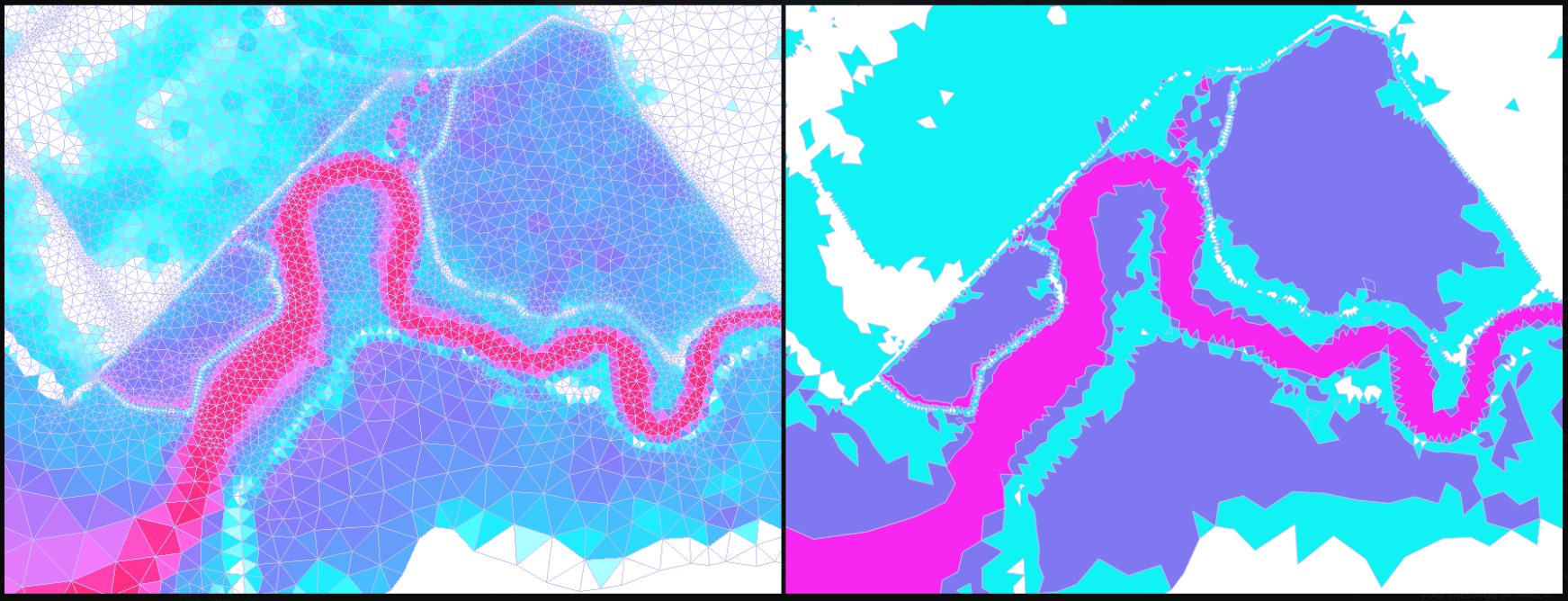
| 2D overland | The 2D simulation engine has been significantly improved. The Riemann solver has changed from Roe to HLLC method. Handling of flooding and drying has also been improved. Finally, the handling of reconstructed values at element faces has also been improved. Differences of results compared to previous versions are expected, especially using the low order space discretization. The improvements should increase stability and especially remove the overestimation of the current speed at river banks or other steep slopes, sometimes observed in previous releases. |
| 2D overland | A new tool 'Create flood map' is available, to convert 2D flooding results (from .dfs2 or .dfsu files) to a polygon layer, where each polygon represents a group of neighboring cells with the same category of results (e.g. same class of water depth). All resulting polygons are saved in a unique shape file. The tool offers some filters to remove or merge polygons which may be considered too small. The tool is opened from the 'Results' tab in the ribbon. |
| 2D overland | Rasters in .TIF and .TIFF format can be used as source of elevation data for interpolation on the 2D domain, after loading them on the map. |
| 2D overland | New result items related to flux magnitude can be saved in '2D flood statistics' result files. |
| Water Distribution | New options are available to perform water balance computations in the network zones: • In the 'Zones' editor, time series from flow monitoring stations can be associated to specific zones, to estimate the amount of water entering or leaving the zone. • A new tool to estimate the average demand and leakage flow in the zones, based on the flow time series associated with the zones, is available in the 'Demand tools' list from the 'WD network' tab in the ribbon. • A new tool to estimate the demand pattern in the zones, based on the flow time series associated with the zones, is available in the 'Demand tools' list from the 'WD network' tab in the ribbon. It can produce several daily or weekly patterns per zone. |
| Water Distribution | VSD pumps can now be controled by the computed flow in a selected pipe, pump or valve. |
| Water Distribution | Two new derived result items are available, respectively named 'Accumulated Flow' and 'Accumulated Fow (Absolute)'. They provide time series of volume accumulated over time, computed from link flow time series. |
| Water Distribution | Carbon emission computed during cost analyses is no more a derived result, but a result computed during the simulation and saved to the result file. Therefore, the accuracy of this result item no longer depends on the saving frequency of the results. |
| Water Distribution | New special selections are added to the 'Map' tab of the ribbon, for use with 'Optimization' and 'Autocalibration' special analyses. These new special selections allow to select network items used in the selected controls or targets from the 'Optimization' and 'Autocalibration' editors. |
| SWMM | A ‘Change type’ button has been added to the ribbon in the ‘CS network’ tab, to convert links to other types. |
| SWMM | A new ‘Slope’ field has been added to the ‘Conduits’ editor. Slopes are computed for all conduits when pressing the ‘Calculate’ button. Calculated slopes can be displayed as X-axis data under a profile plot. |
Fixed issues
| Modul/Typ | Fehler |
|---|---|
| General | Various improvements or corrections have been made to the import from MIKE URBAN, MIKE HYDRO River, MIKE11 or MIKE FLOOD model setups. This especially includes automatic conversion of MIKE FLOOD couplings between CS pumps and river, to connections between the CS and the river networks. |
| General | The performance of the ‘Versions management’ tool has been improved. The execution of the tool is much faster when reporting large numbers of differences. |
| General | When exporting a profile plot view to a CAD file, the exported axes were wrong if the profile plot window was not zoomed to the full extent prior to the export. |
| General | While editing the symbology for map layers from a geodatabase, using the ‘Unique values’ symbology type failed to show the list of fields available for the layer. |
| General | While editing the symbology for map layers from a CAD file with the ‘Unique values’ symbology type, the ‘Add all’ button failed to show the correct list of unique values. |
| General | Displaying WMS server layers on the map is faster. |
| General | Displaying background images on the map is faster, especially with TIF images. |
| General | An unexpected error occurred when loading a map layer's symbology from a file, if the 'Symbology settings' editor was opened. |
| General | The option 'Zoom to full extent' in the profile plot did not actually zoom out to the entire extent. |
| General | The speed of the 'Import and export' tool has been improved when importing data on the local machine to a PostGIS database on a distant server. |
| General | MIKE sometimes stopped working when using the Identify tool with a CAD file loaded on the map. |
| General | Several corrections have been made to the 'ArcGIS Integration' to correct exported layers. |
| General | Deleted parts of the pipe network were sometimes still visible in the 'Network overview', when zooming out. |
| General | An error message was shown on the map when displaying labels showing the content of a user-defined expression column. |
| General | The .mupp file became corrupt if it was saved while the 'Versions management' tool was opened. |
| General | In the 'Import and export' tool, the Copy / Paste options in the context menu didn't properly copy condition expressions, if any. |
| General | While loading a result file, the "Ts file properties" window failed to show the actual start time of the selected result file. |
| General | Saving an animation of results to .avi file did not work if the Map window was not in focus. |
| General | When comparing results time series from different files at the same location, the time series plot's table can now show the file names in the header of the table. |
| General | In the 'Interpolation and assignments' tool, the method 'Assignment from network neighbours' did not work with text string data. |
| General | The location of tiles was not always cleared on the map after using the tool 'Combine tiles'. |
| General | The 'Model and result report' tool didn't allow to join input data with derived results. |
| General | When exporting a layer to shape file from the map, the exported layer contained wrong locations if the MIKE+ setup is defined in a SI unit system but with a coordinate system defined in US units. |
| General | The 'Versions management' tool sometimes reported an unexplained failure while updating a model version. |
| General | Snapping to the network (e.g. to connect a pipe to node) stopped working after using the 'Measure' tool. |
| Collection System | Pattern values were not correctly applied in the simulation if the pattern definition table was not sorted by increasing time. The simulation is now independent from the sorting. This pattern definition table has also been reviewed to better show the time span covered by each multiplier. |
| Collection System | Water level was filled below the bottom level of the pipe, if the pipe invert level is higher than the connected node's bottom level. |
| Collection System | The 'Critical level' shown on profile plots was a point layer, and is changed to a line layer. |
| Collection System | In the 'Curves and relations' editor, the Volume data from 'Basin geometry' tables are now plotted with intermediate interpolated points to better show the volume changes as considered in the simulation. |
| Collection System | New merged catchments created from the 'Network simplification' tool had their 'Network type' always undefined. |
| Collection System | After merging catchments with the 'Network simplification' tool, the 'Load type' of corresponding catchment connections was incorrect. |
| Collection System | In the 'Connection tool', a new 'Target network type' filter has been added to control which types of nodes or pipes can be connected. |
| Collection System | Nodes of type 'Basin' could not be renamed more than once. |
| Collection System | A wrong unity type was shown for values in the 'Boundary conditions' editor for boundary type 'Exfiltration from node'. |
| Collection System | The ‘Network simplification’ tool considered some pipes as unliked and removed them during trimming operations, although they were connected to the rest of the network. |
| Collection System and Rivers | The expression of ‘Variable expression’ sensors, used in combination with the Control module, was limited to 40 characters. This length has been increased to accommodate longer expressions. |
| Collection System and Rivers | An unexpected error was reported when trying to run a simulation including control rules, if two or more actions referenced the same table from the ‘Curves and relations’ editor. |
| Collection System and Rivers | It was not possible to load manually a rainfall-runoff result file, when catchments use a combination of hydrological models (with RDI). |
| Collection System and Rivers | After updating catchments properties using the 'Import and export' tool, the catchments were unexpectedly moved on the map. |
| Collection System and Rivers | Link water level was not shown on profile plots, in some parts of natural channel or river networks. |
| Collection System and Rivers | The simulation failed when 'Accumulated inflow’ or 'Accumulated outflow' result items were saved to result files. |
| Collection System and Rivers | An unexpected error occurred when opening the 'Boundary overview' when some boundary conditions are set to use a SWMM result file as input. |
| Collection System and Rivers | Some results were not refreshed after re-running a simulation when results are saved to a custom folder with relative path. |
| Collection System and Rivers | The 'Catchment processing' tool computed incorrect imperviousness values in case of overlapping shape files. |
| Collection System and Rivers | The 'Catchment processing' tool computed incorrect imperviousness values when using multi-part shape files. |
| Rivers | When moving a cross section with the option ‘Recompute coordinates’, the new coordinates were wrong if markers 1 and 3 were not set to the end points of the cross section. |
| Rivers | When creating cross sections from survey points using the tool ‘Create and update cross sections’, the generated cross sections sometimes wrongly extended on the map until they reached other parts of the river on the other side of a meander. |
| Rivers | The river bottom level shown on profile plots used to be the level of the marker 2 in the cross sections. This was possibly different than the bottom level, and profile plots now show the lowest level found between markers 1 and 3 in the cross sections. |
| Rivers | An error related to DEM file path was sometimes issues when interpolating results on a 2D map. |
| Rivers | Some river structures were deleted when their containing river was split. |
| Rivers | Closed cross sections were always shown on the map as a very short line, instead of showing the actual cross section's width. |
| 2D overland | When converting input rasters to .dfs2 files using the ‘Combine DEM tiles’ tool, the created .dfs2 file was not suitable for use as input topography for interpolation of the 2D domain, due to a ‘Land value’ being set too low in this file. The .dfs2 file is now created with a ‘Land value’ set higher than the maximum elevation in the file, so that all cells are included in the interpolation. |
| 2D overland | When importing 2D culverts from a shape file, the selected ID attribute from the shape file is now used to name the created culverts. |
| 2D overland | The tool ‘Exclude rivers’, used to exclude the river extent from the 2D domain, failed for rivers having negative chainages. |
| 2D overland | In the ‘2D domain’ editor, the option ‘Edit in Mesh Generator’ to edit a flexible mesh sometimes led MIKE+ to not respond. |
| 2D overland | The 'Depth threshold value' used for '2D flood statistics' result files did not accept decimal values. |
| 2D overland | The simulation reported a syntax error when an open boundary was not correctly located on the borders of the mesh or if its location was missing. The workflow for creating 2D boundary conditions has been improved to avoid this situation. |
| 2D overland | The simulation failed to start when including a 'Single distributed source' boundary condition associated with a time series. |
| 2D overland | The symbology editor did not allow applying the 'Unique value' symbol type for the 2D boundary conditions layer. |
| 2D overland | Importing multiple dikes using the 'Insert from file' button, and selecting a multi-part shape file, caused MIKE+ to stop working. |
| Water Distribution | The 'Stop' button, used for cancelling a simulation, was always disabled during Cost Analysis simulations. |
| Water Distribution | The 'Demand Statistics' reported wrong values for some model setups. |
| Water Distribution | Saving results to a custom folder could not create folders with relative path. |
| Water Distribution | While deleting a pipe, associated controls were not deleted. |
| Water Distribution | The 'Aggregation tool' window became invisible with some operating systems because it was placed in the background of the applications. |
| Water Distribution | Flushing Analysis simulations did not work properly when point is used as decimal separator. |
| Water Distribution | Fire flow calculations were wrong when the search for critical nodes is activated. |
| SWMM | Several corrections have been made to the import from .inp file and export to .inp file. |
| SWMM | External time series in .dat format were not supported when they didn’t contain a header row. |
| MIKE 1D engine | Fixed error in rainfall-runoff summary when running RDI (TT62253). |
| MIKE 1D engine | Fixed error in long-term simulation job re-do feature when running RDI (TT63131). |
| MIKE 1D engine | Fixed errors in culvert flow conditions calculation (TT63458, TT63813). |
| MIKE 1D engine | Fixed error occurring when running data assimilation with weighted rainfall (TT63477). |
| MIKE 1D engine | Fixed error when loading RDI calibration data after simulation (TT63511). |
| MIKE 1D engine | Enabled conversion to relative path for data assimilation observation file when updating m1dx file to release 2024 (TT6329). |
| MIKE 1D engine | Corrected unhandled exception occurring when applying grid-distributed weights with a time-varying rain grid (TT64026). |
| MIKE 1D engine | Fixed bug in natural flow initial condition (TT64049). |
| MIKE 1D engine | Enabled calculation of transverse flow area in basins to support ECO Lab water quality calculations (TT63779). |
| MIKE 1D engine | Fixed error in Analyze Network tool resulting in NaN values (TT64001). |
| MIKE 1D engine | Fixed error causing results from failed jobs to be written to the long-term simulation statistics output file (TT63495). |
| MIKE 1D engine | Updated html continuity balance to include contributions from lateral links located along collection system ‘natural channels’ (TT64129). |
| Couplings engine | Fixed instability occurring at source links (TT63595). |