Benutzer-Werkzeuge
Neu in MIKE+ 2023 – inklusive Update 1
Auf dieser Seite beschreiben wir die wichtigsten Verbesserungen und Neuheiten von MIKE+ 2023 (ohne Anspruch auf Vollständigkeit).
Angaben zu älteren Versionen finden Sie in der MIKE+ Versionsgeschichte.
Allgemeine Änderungen
Speichern Sie Ihr Ergebnislayout, ohne eine Datenbank öffnen zu müssen
Wenn Sie MIKE+ als Ergebnisviewer verwenden (es wird kein Modell-Setup geöffnet - und es ist keine Lizenz erforderlich), ist es jetzt möglich Ergebnisse anzuzeigen, und das Fensterlayout kann nun als *.mupp gespeichert und wieder geöffnet werden. (Update 1)
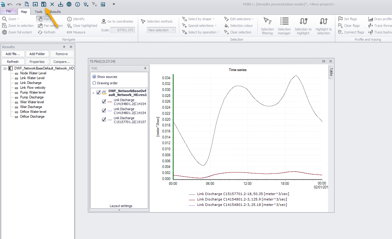
Erstellen Sie Ihre eigenen benutzerdefinierten Spalten mit Simulationsergebnissen
Vereinfachen Sie Ihren Arbeitsablauf, indem Sie die Simulationsergebnisse bequem neben Ihren Eingabedaten in denselben Editoren anzeigen.
Wasserversorgung
Neuer Modul zur automatischen Kalibrierung von Wasserversorgungsnetzen

Der neue Modul vergleicht modellierte Drücke und Durchflüsse mit gemessenen Werten, entweder stationär oder als Ganglinie, und passt wahlweise folgende Modellparameter an, um eine optimale Überseinstimmung zu erzielen:
- Anpassung der Rauheiten pauschal oder für Gruppen von Rohren
- Öffnen und Schließen von Rohren oder Schiebern
- Skalierung von Ganglinien zur Anpassung des Verbrauchs
- Anpassung der Emitterkoeffizienten zur Modellierung von Verlusten
Oberflächenabfluss
Die folgenden Verbesserungen kommen der Modellierung von Fließgewässerm und von Kanalnetzen zu gute.
Abflussbildung gemäß Landnutzung
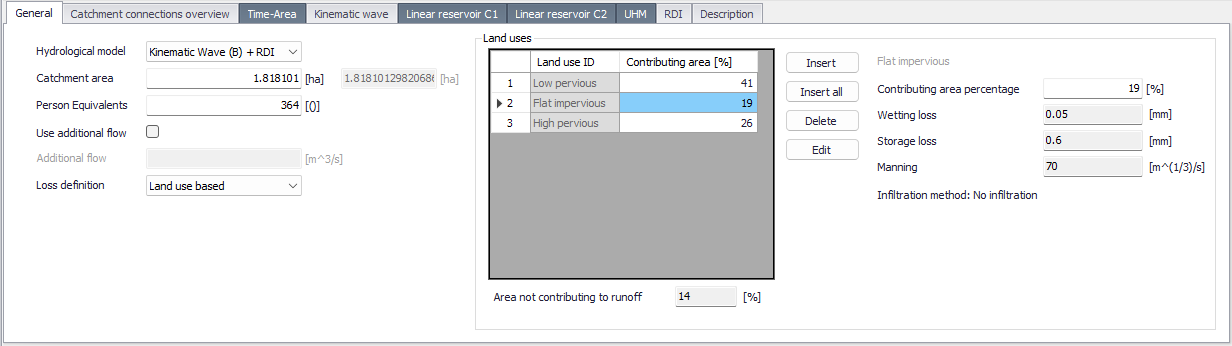
Die Ansätze der Abflussbildung (hydrologischen Verluste und Versickerung) lassen sich nun über die Landnutzung steuern, und zwar unabhängig von der Abflusskonzentration. Pro Einzugsgebiet können eine oder mehrere Arten der Landnutzung festgelegt siehe werden. An die Landnutzungsarten sind Anfangsverluste und Versickerungsparameter geknüpft, siehe Handbuch Kapitel 4.2.7. Zum Versickerungsmodell nach Horton gesellt sich nun Green-Ampt hinzu.
Die Modelle A, B und C sind nur mehr für die Abflusskonzentration verantwortlich, also Zeit-Flächen-Diagramm, oder Kintematische Welle, oder Linearer Einzelspeicher.
Beispielsweise lässt sich das beliebte Modell A auf dem Weg über die Landnutzung um Versickerungsparameter erweitern.
Die Anteile der Landnutzung an den Einzugsgebieten müssen derzeit noch extern via GIS ermittelt und importiert werden. Ein Tool in MIKE+ wird für die Version 2024 erwartet.
Interpolation von Regen zwischen den Stationen
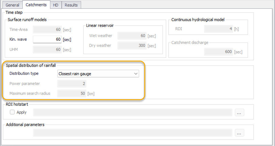
Wenn Sie die räumliche Verteilung von Niederschlagsergeignissen mit Hilfe von mehreren Regenmessern modellieren, wurde bisher jedes Einzugsgebiet
- dem nächsten Regenschreiber
zugeordnet. Mit Update 1 stehen Ihnen zwei neue Methoden der räumlichen Interpolation zur Verfügung:
- Thiessen-Polygone
- Inverse Distanzwichtung
Die Methode wird im Simulationsdialog unter den Einzugsgebietsparametern festgelegt, siehe Handbuch Kapitel 14.1.2
Fließgewässer 1D
Erweiterung des Sedimenttransports in Fließgewässern

Sedimenttransport war bisher auf die in der Kanalisation angewandten Ansätze beschränkt. Nunmehr können Sie auch die Ansätze aus der Fließgewässermodellierung verwenden, die bisher MIKE 11 und MIKE HYDRO River vorbehalten waren.
So wird nun in den einzelnen Sedimentfraktionen zwischen kohäsiven und nicht-kohäsiven Sedimenten unterschieden, und die verwendeten Formeln für Transport entlang der Sohle und Transport mit der schwimmenden Welle können entsprechend angepasst werden. Die Schichtung der Ablagerungen kann beeinflusst werden, wie deren Anfangsbedingungen.
Unser zweiminütiges Video gibt einen guten Eindruck.
MIKE+ 2023 Update 1 Release Notes
New Features
| Module/Typ | Neues Feature |
|---|---|
| General | A new 'Help' list has been added to the 'File' menu, providing links to various sources of information hosted online and related to MIKE+. |
| General | While importing model setups from the File \ import menu (e.g. from MIKE URBAN, MIKE HYDRO River, EPANET, etc.), all messages related to this import and reported in the log view are now also saved to a text file, for future reference. This text file is saved in the folder containing the MIKE+ database. |
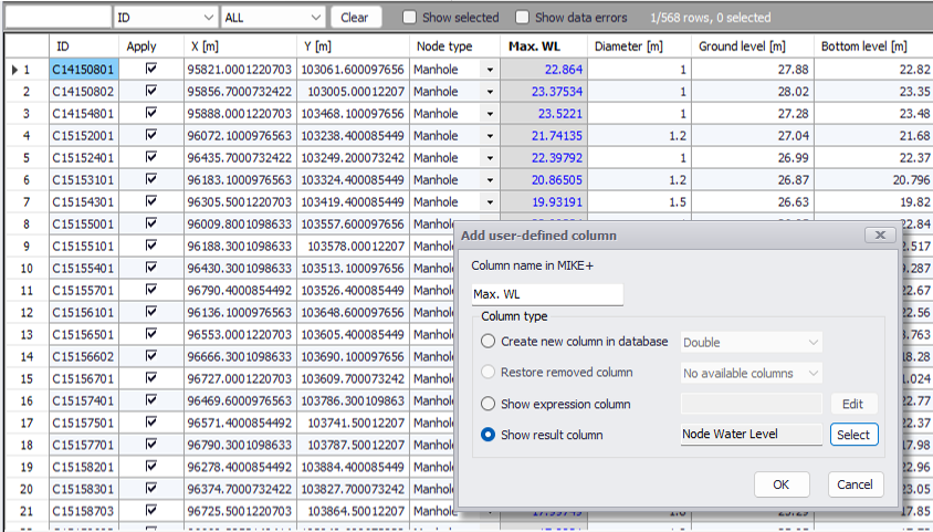
| General | The option to add user-defined columns to the overview table in the editors, has been extended to show on the fly results from a selected result item. This allows comparing input data with results in a common table. This functionality is available for pipe network editors only (MIKE 1D Collection System, SWMM, Water Distribution). |
| General | The 'Field calculator', used to edit items in the overview table in the editors, now allows to built expressions using user-defined columns containing expressions or results. |
| General | The 'Plots and statistics' editor has been reviewed. It now contains a new set of calibration criteria, as well as options to control the time frame for which the statistics are computed. A problem making this editor slow in some cases has also been resolved. |
| General | A new button to zoom to specified XY coordinates on the map has been added to the 'Map' tab of the ribbon. |
| General | When MIKE+ is opened in results presentation mode (no model database opened), it is now possible to save the .mupp file, which allows saving and restoring the layout of the result windows. |
| General | The workflow for executing simulations in MIKE Cloud has been improved, so that it is no longer required to manually export the simulation files to be uploaded to the cloud. The simulation files from the active simulation are now automatically prepared for upload, when using the 'Run in MIKE Cloud' button. |
| General | Minor improvements have been made to the 'Versions management' tool. The main dialog to manage the list of versions has a new option to create a child using an existing model version, and shows the last modification date of each model instance. The 'Update' tool includes new functionalities to handle conflicts: a new action 'Restore reference', a new button 'Zoom to active' to view the map location for each listed conflict, and a 'Show record's attributes' button to view the differences between the various model versions. |
| General | The 'Results table' windows can now include columns of results from different result files for comparison. |
| General | The 'Results table' windows can now include user-defined columns, to perform operations between result columns and/or network properties. |
| General | After opening a MIKE+ project, if the path to a map layer is broken and the layer cannot be displayed, a new option in the layer's context menu allows to reselect the input file with its new path. |
| Collection System | The presentation of water filling in profile plots has been improved, so that the filling is limited by the actual height of the pipes and the filling also occurs in the nodes. |
| Collection System and Rivers | In the 'Catchments' editor, a new option for specifying loss and infiltration properties as a function of the land uses on the catchment is available. This new method can be used in combination with hydrological models 'Time area', 'Kinematic wave' or 'Linear reservoir'. This method allows to separate the specification of the routing process (controlled by the selected hydrological model) and the infiltration process which is now defined in a new 'Land uses' editor for each type of land use. |
| Collection System and Rivers | A new option in the 'Simulation setup' definition allows to control how rainfall time series are applied to catchments for Rainfall-Runoff modelling: either applying the closest rainfall time series to each catchment, applying weighted time series using the Thiessen polygons method, or applying weighted time series using an inverse distance weighting method. |
| Collection System and Rivers | When connecting catchments to the network from the map, the 'Connect catchment' button in the ribbon offers two different modes: either add to existing connections, or replace all previous connections. |
| Collection System and Rivers | For Rainfall-Runoff modelling with the RDI hydrological model, additional options are available in the 'Parameters RDI' editor. It especially includes additional options for the snowmelt processes (effect of solar radiation, heat transfer from rainfall, use of elevation zones), effects of irrigation on the catchment, and definition of seasonal variation for some of the RDI parameters. |
| Collection System and Rivers | A new option in the 'Simulation setup' editor allows to run water quality simulations based on a hydrodynamic result file, instead of running both hydrodynamic and water quality conditions simultaneously. The decoupled approach can significantly speed-up the water quality simulation. |
| Collection System and Rivers | Hydrodynamic results can now be saved as time series to a text file. |
| Collection System and Rivers | Water Quality modelling with MIKE ECO Lab now allows using several MIKE ECO Lab templates, with shared state variables. This allows the various templates to interact one with another. |
| Rivers | The 'Sediment transport' module can now be applied on river networks. This module now offers a 'Basic morphological analysis' mode, with limited options and primarilty designed for pipe networks, and an 'Advanced morphological analysis' mode, providing additional options designed for river applications. |
| Rivers | The cross sections tool 'Export to text' now offers a new option to export marker levels and coordinates to text file, for all or only the selected cross sections. |
| Rivers | A new button 'Insert all rivers' in the 'Boundary conditions' editor can automatically insert all missing boundary conditions on river ends. |
| Rivers | Profiles representing elevations from markers 4 and/or 5 in the cross sections, can now be presented on profile plots. |
| Rivers | A new option in the 'General' tab of the 'Cross sections' editor allows to plot elevations from a selected DEM for comparison with the active cross section. |
| Rivers | A new option has been added to the 'Create and update cross sections' tool, to set markers in cross sections at intersections with polylines (alignment lines) from a shape file. |
| Rivers | It is now allowed to define rivers with identical names, if their respective range of chainages don't overlap. |
| Rivers | When renaming a river, cross sections are updated accordingly with the new river name. |
| Rivers | Cross section labels (cross section location or ID) can now be shown on profile plots. |
| Rivers | Control rules now support the action 'Apply natural flow' (ignoring the structure's head loss) for weirs and culverts. |
| 2D overland | A new button '2D cross section plot' has been added to the '2D Overland' tab of the ribbon. It allows drawing cross sections from the 2D domain, along polylines drawn on the map. This 2D domain cross section can be combined with a river cross section. It can also draw simultaneously elevations from a DEM. |
| 2D overland | A new type of 2D overland result file (content type 'Section statistics') has been added, saving maximum inundation results along a horizontal line. |
| 2D overland | '2D flood statistics' result files can now also save the maximum water level throughout the simulation period. |
| 2D overland | Two new options have been added to the list of 'Special selections' in the Map tab of the ribbon, respectively to select 1D-2D couplings associated to selected network items and to select network items associated to selected 1D-2D couplings. |
| 2D overland | A new 'Split' button in the 'Coupling tools' tab of the ribbon allows splitting 'River bank' and 'Natural channel' couplings. |
| 2D overland | After closing MIKE+ and continuing a simulation in the 'Launch simulation engine' window, it is now possible to launch simultaneously another simulation from the same MIKE+ project (the simulations no longer use the same log file names, which previously led to conflicts). |
| Water Distribution | A new 'Autocalibration' special analysis has been introduced. Autocalibration uses optimization algorithms to find optimum pipe friction coefficients, locate closed isolating valves, adjust water consumptions and/or find point leakages, in order to improve the match between model results and measurements. |
| Water Distribution | A new 'Regulation overview' editor gives an overview of all the simple controls defined on pipes, pumps, valves or turbines. |
| Water Distribution | The 'Cost analysis' editor has been reviewed, especially to better control which simulation ID is associated to the analysis and to report results per pump station, if any is defined in the network. |
| Water Distribution | The workflow associated to the 'Demand allocations' editor has been reviewed. The 'Geocode' tab is now replaced by the 'Connection' tool and the 'Aggregation' tab replaced by a new 'Aggregation' tool. Both tools are available either from the ribbon ('WD network' tab) or from the 'Demand allocations' editor. |
| Water Distribution | In the 'Connection' tool, the method 'To node by pipe ID' has been enabled. It is used to connect demand allocations to the closest node on a pipe with the same name as the demand allocation. |
| Water Distribution | The 'Generate' button from the 'Zones' editor, which creates zones from shape files, has been improved to also create zones of type 'Network'. |
Fixed issues
| Module/Typ | Fehler |
|---|---|
| General | Various improvements or corrections have been made to the import from MIKE URBAN, MIKE HYDRO River or MIKE11 model setups. This especially includes improvements to the scenarios imported from MIKE URBAN, and automatic creation of Storages on the river network when importing MIKE 11 models including link channels with storages. |
| General | An unexpected error occured in MIKE+ 2023 when trying to save a project file, if an image was added to the map. |
| General | Profile plots saved with the project could not be restored when reopening. |
| General | Some memory usage issues occuring when using large raster files, leading to MIKE+ becoming slow, have been improved. These issues especially occured when using a large .dfs2 files as 2D domain, or in tools 'Trace rivers from DEM' and 'Catchment delineation'. |
| General | In the 'Versions management' tool, the 'Compare' function failed to show database differences on the map, with un expected error message. |
| General | The 'Versions management' tool did not work with model databases saved on remote / network locations. |
| General | Changes made to expressions of 'user defined columns' were not saved to the database and therefore not restored after saving and reopening. |
| General | The path selected between flags to locate profile plots was sometimes not the expected one, in particular when structure links were involved. A new path selection logic is now used, selecting the path with the smallest number of links. |
| General | When loading results data from result files, the user-defined time period to load was ignored if derived results were selected, and the whole time period was therefore loaded. |
| General | The 'Results differences' tool prevented from selecting other result file types than MIKE 1D results, when using the Chinese version of MIKE+. |
| Collection System | The 'Results differences' tool showed in one case a wrong input time series and therefore reported a wrong difference. |
| Collection System | The Profile plot window failed to show the 'Slope' value in links, in the data table below the plot. |
| Collection System | The 'Project information' window didn't report the exact sum of pipes volume for pipes with egg shape. |
| Collection System | The Report tool failed in some cases to report differences between alternatives, with an unexpected error message. |
| Collection System | The profile plot window sometimes failed to show elevations from a DEM. |
| Collection System and Rivers | While defining actions for the control rules, the 'PID input' field was limited to 40 characters, which was too small for some expressions. This limitation has been increased. |
| Collection System and Rivers | The 'Boundary overview' editor sometimes took a very long time to open and show the list of boundary conditions. |
| Collection System and Rivers | In the 'Catchments' editor, the tabs for the linear reservoir methods C1 and C2 have been slightly redesigned, to better reflect that some parameters from the parameter sets are used also when working with local parameters defined in the catchment. |
| Collection System and Rivers | An unexpected error sometimes occured when trying to edit the condition expression, for a control rule. |
| Rivers | It is now possible to show labels on the map, for the cross sections layer. |
| Rivers | When exporting the cross sections layer to shape file from the 'Layers and symbols' tree, all global properties of the cross sections are now exported as attributes. |
| Rivers | Result items saved in structures are now presented and grouped by item type (e.g. when selecting result time series to plot). |
| Rivers | In the profile plot window, the water level simulated in the river was sometimes plotted with a wrong elevation. |
| Rivers | The extent of the active cross section (from marker 1 to marker 3) was inaccurately shown on map. |
| Rivers | Connection lines between catchments and rivers always connected on the map to the middle of the river, and didn't reflect the actual connection location used in the simulation. The connection lines on the map now show the chainages of the connections. |
| 2D overland | In the 2D overland volume balance summary, the flow through culverts was wrongly reported as an error correction. |
| 2D overland | The 2D domain's symbology palette sometimes turned to zero values for all elevation ranges when reopening the project. |
| 2D overland | For Water Quality simulations, the component's concentration associated to distributed source boundary conditions was incorrect, as it didn't match the user-defined value specified in the '2D WQ boundaries' editor. |
| 2D overland | When using the Chinese version of MIKE+, it was not possible to exclude from the mesh the polygons provided in a shape file. |
| SWMM | Some rainfall time series files were not accepted by MIKE+ despite being in a valid .dat format. |
| SWMM | When splitting a conduit on the map, the new levels at the split location were copied from the upstream / downstream levels of the original pipe, instead of being interpolated. This led to a wrong profile of elevation. |
| Water Distribution | Storage tank volume is now reported as a result from fire flow analyses. |
| Water Distribution | The tool 'Time series from map' failed to select pipes on result maps. |
| Water Distribution | Profile plots showed wrong pipe diameters when no model database was opened. |
MIKE+ 2023 Release Notes
New Features
| Modul/Typ | Neues Feature |
|---|---|
| General | New unit systems are available for 'Rivers, collection system and overland flows' model type. They control the unit for discharge and volume values in input editors and in results presentation windows. |
| General | The 'Apply' option in 'Rivers, collection system and overland flows' model type and the 'Is active' option in the 'Water Distribution' model type have been added to all relevant editors. When this option is unselected, the corresponding items will be ignored in the simulation without having to create scenarios. |
| General | User-defined columns are now automatically imported from MIKE URBAN setups. |
| General | The 'Import and export' tool allows importing data to and exporting from user-defined columns. |
| General | The 'Import and export' tool offers a new transfer mode to skip the import of records already existing in the target MIKE+ database. |
| General | MIKE+ can now open a .sqlite database even if it doesn't have a corresponding .mupp file. The .mupp file will be created automatically. |
| General | The 'Interpolation and assignment' tool can use feature layers in .xyz format as source for interpolation of data. |
| General | The 'Network simplification' tool can be executed from a command line. |
| General | Any scenario can be converted to a Base scenario, in a new database. This new option is accessible in the context menu of the scenarios tree. |
| General | A new 'Combine tiles' tool has been added to the 'Tools' tab of the ribbon. It merges multiple DEM tiles into a single DEM file for later use in MIKE+. |
| General | In the 'Versions management' tool, the 'Compare' and the 'Update' tools have a new 'Filter on model type' which allows to analyse only the tables relevant for the active features and modules in the project. |
| General | In the 'Versions management' tool, the 'Compare' and the 'Update' tools can compare networks with merged pipes to their original network, to avoid considering merged pipes as new pipes. |
| Results visualization | The 'Results differences' tool can compare link results on networks with merged pipes to results obtained with the original network. |
| Results visualization | The 'Results differences' tool can now also analyse results differences between Water Distribution results (.res files) or between SWMM results (.out files). |
| Results visualization | The 'Compare' button in the 'Results' tree view, used to create a result file with differences between two source files, now supports the following types of files: MIKE 1D results (.res1d), 2D Overland (.dfs2, .dfsu), Water Distribution (.res, .resx), SWMM (.out). |
| Results visualization | 2D Overland results (.dfs2, .dfsu files) can be presented on result maps. It is therefore possible to visualize 2D result maps without opening a model database. |
| Results visualization | The 'Results tables' window has been redesigned. It provides a clearer presentation of tabular data, options to show statistical values for each result location, and new options to select model data based on results selection or vice versa. |
| Collection System | Roughness values can be specified in Manning (n) instead of Manning (M), when defining catchments or pipes and canals. |
| Collection System | SWMM runoff result files (.out) and SWMM outflow interface files (.txt) can be used as input file for 'Inflow from result file' boundary condition in 'Rivers, collection system and overland flows' network simulation. |
| Collection System | A new routing option is available in the 'Catchment connections' editor, to introduce some time delay and attenuation of the runoff hydrograph before it enters the network. This option can be enabled from the 'Network simplification' tool, for catchments which are reconnected after a trimming operation. |
| Collection System | A new button 'Update markers' has been added in the 'Generic shapes' editor for automatically inserting markers at default locations in shapes with type 'X-Z-R-M Open'. |
| Collection System and Rivers | The 'Wave approximation' numerical solution can be changed for selected pipes or rivers, in the 'Pipes and canals' and 'Rivers' editors. |
| Collection System and Rivers | A new 'Variable expression' type of sensor is available in the 'Control rules' module. It allows defining sensors with an advanced user-defined expression, typically as a function of other sensors. The result time series of this sensor can be saved in result files. |
| Collection System and Rivers | A new 'Analyse network' tool is available in the 'Simulation setup' editor for network simulations. It aims a finding and reporting locations prone to instabilities, in order to improve the model stability. Improved stability allows running simulations with longer time steps, therefore resulting in shorter simulations. |
| Collection System and Rivers | When importing a full MIKE FLOOD setup, the River/Urban links from MIKE FLOOD are now converted to connections between the river and the collection system network. |
| Collection System and Rivers | For catchments modelled with the 'RDI' rainfall-runoff method, it is possible to enable an autocalibration of the RDI parameters against a discharge measurement time series. Autocalibration is enabled in the 'RDI' tab in the 'Catchments' editor, and the calibration settings are defined in the 'Parameters RDI' editor. |
| Collection System and Rivers | The symbology for catchment connections can now be customised. |
| Collection System and Rivers | A new type of initial conditions definition, using 'State files', is available in the 'Simulation setup' editor for network simulations. State files are special result files saving detailed information for later use as initial conditions, and therefore need to be saved during a previous simulation. To save state files, a simulation must contain a result file with the new content type 'State files (initial conditions)'. |
| Rivers | A new 'Steady state' type of initial conditions is available in the 'Simulation setup' editor for river simulations. |
| Rivers | For boundary conditions of type 'River Q/h relation', a new 'Compute' button allows estimating the Q/h relation table based on cross section geometry at the boundary location. |
| Rivers | A new type of boundary condition 'Groundwater leakage' is available for river networks. |
| Rivers | A new plot has been added to the 'Culverts', 'Weirs', 'Gates' and 'Bridges' editors. It provides a graphical view of the structures geometries along with their upstream and downstream cross sections, for comparison. |
| Rivers | The main river boundary condition types are now visible on map using new dedicated map layers. |
| Rivers | Muskingum and Muskingum-Cunge routing methods are available for rivers. Routing location and method are specified in the 'Routing' tab of the 'Rivers' editor, after defining the river type as 'Simple routing'. |
| Rivers | Couplings between rivers and MIKE SHE can now be defined in the new 'MIKE SHE couplings' editor. It is enabled by activating the 'Coupling to MIKE SHE' option in the 'Model type' editor. After setting up a river model including such couplings, the .m1dx simulation file must be exported from the File \ Export menu, for use in MIKE SHE. |
| Rivers | A new tool 'Trace rivers from DEM' has been added to the ribbon, in the 'River network' tab. It is used to create new rivers, following highest slopes from a Digital Elevation Model. |
| Rivers | The 'Catchments delineation' tool has been extended to allow creating catchments for river networks, based on a Digital Elevation Model. |
| Rivers | The 'Bed roughness' editor now has a new type of roughness distribution, based on multiple zones on the vertical axis. It also includes a new 'Roughness factors' tab to define constant or time-varying factors to the bed roughness. |
| Rivers | A new tool 'Interpolate resistance' has been added to the ribbon, in the 'River network' tab. It is used to spatially interpolate bed roughness values and apply them to cross sections. |
| 2D overland | In the '2D boundary conditions' editor, the 'Source' type of boundary offers a new 'Q/h relation' type of definition, designed to specify an outflow value as a function of the water level. |
| 2D overland | 'Saturation' can now be saved as a new result item in 2D result files. |
| 2D overland | The numerical scheme for the hydrodynamic calculations using the higher-order scheme has been improved (improvements to the well-balanced scheme; including velocity-based reconstruction of face values), to improve the simulation's stability. This may result in differences of results after updating to this new version. |
| 2D overland | The performance of simulations using GPU acceleration has been improved, to reduce simulation times. |
| 2D overland | The initialisation phase is now faster for simulations with infrastructures defined with shape files including many thousands of polygons (for example, house footprints to be included in the calculation). |
| 2D overland | Stability has been improved for free outflow boundary conditions. |
| 2D overland | The log file from 2D overland simulations better reports locations of errors related to 1D-2D couplings, with clear indication of river ID and chainage or node ID. |
| Water Distribution | It is possible to export the network and results data shown on the Profile plot window to a text file. This new option is accessible from the context menu of the Profile plot windows. |
| Water Distribution | In the 'Network simplification' tool, filters are now available in a new 'Select to exclude' tab, to exclude some network element types from the simplification. |
| Water Distribution | In the 'Optimization' special analysis, new target types have been introduced: 'Water quality', 'Pump power', 'Pump energy cost' and 'Pump speed'. |
| Water Distribution | A 'Level control' option has been added to TCV valves to model float valves. |
| Water Distribution | The 'Connection tool' is now available in the 'WD network' tab in the ribbon, to connect demand allocations and measurement stations to the network. |
| Water Distribution | A new special selection 'Pipes connected to selected nodes' has been added. |
| Water Distribution | The 'Zone mapping' tool offers a new option to separate zones based on pipes with user-selected criteria. |
| SWMM | Catchment connection lines are now visible on the map. |
| MIKE 1D engine | Changed behavior of pump sump to use pump stop level for setting initial water level of pump (TT61508). |
Fixed issues
| Modul/Typ | Fehler |
|---|---|
| General | Various unexpected errors, popping up in different situations, have been fixed. |
| General | The pipe direction was unexpectedly taken into consideration when performing a network simplification. As a consequence, pipes could not be merged when they were defined in opposite direction. This pipe direction criterion has been removed. |
| General | Results values shown in X-axes data under a profile plot, were not refreshed when animating results. |
| General | The 'ArcGIS integration' sometimes failed to export geometry data for 1D result layers. |
| General | The 'ArcGIS integration' sometimes failed to export results from 2D result files in .dfsu format. |
| General | An unexpected error could show up when loading some .TIF files as an image layer on the map. |
| General | When joining model data and results in a report table, the table contained some attributes which were not selected in the report settings. |
| General | Levee elevation shown on the Profile plot for pipes defined with a generic shape was wrong, if the last two points defining the shape have the same X-value. |
| General | While running a simulation, the remaining simulation time was always shown in accumulated seconds. It is now shown in hours, minutes and/or seconds. |
| General | Exporting 1D-2D couplings to shape file using the option 'Export selected layers to shape file' from the layer's context menu failed. |
| General | Using the context-menu option 'Show validation items on map', more error locations than expected were shown on the map. |
| General | Working with the 'Use single editor style', clicking the 'Simulation setup' button in the ribbon opened the last opened editor instead of the 'Simulation setup' editor. |
| General | There was an error in the license usage, preventing from importing a MIKE URBAN model into MIKE+ when having only one seat available in the license. |
| General | The same file format for saving symbology configuration can now be used on the main Map and on result maps. |
| General | The 'Preprocessing Temporal Data' tool from the 'MIKE Zero toolbox' always failed during execution. |
| Collection System | Profile plots failed to show results in locations with parallel pipes. |
| Collection System | Catchment connections to 'River junction' nodes triggered an unexpected error when starting the simulation. |
| Collection System | The resistance distribution type was undefined for X-Z cross sections imported from MIKE URBAN setups, instead of being set to 'Uniform'. |
| Collection System | The special selections 'Load points connected to selected nodes/pipes' sometimes selected load points not connected to selected nodes. |
| Collection System | Many unexpected control rules were sometimes imported from MIKE URBAN setups with RTC rules. |
| Collection System | The unit description for values in boundary conditions with type 'Exfiltration from node' was incorrectly showing a discharge unit instead of an infiltration rate unit. |
| Collection System | Points in X-Z cross-sections imported from MIKE URBAN were not sorted by increasing S-coordinate. |
| Collection System | The use of 'Water age' components in the Transport module did not work: the water age remained constant. |
| Rivers | Cross sections were shown on the map even when their chainage was out of the range of the river chainages. |
| Rivers | While selecting result items to be shown in result windows, items from river structures were not correctly categorized, and each structure was presented in a separate category. |
| Rivers | Paths to dambreak time series files were saved as absolute paths in the database, breaking the file paths when moving the database to a new folder location. |
| Rivers | QOF and QIF initial conditions for NAM catchments were imported from MIKE HYDRO River files with a wrong unit conversion. |
| Rivers | While importing full MIKE FLOOD model setups, rivers are sometimes renamed to fulfill MIKE+ requirements, but the river IDs were not renamed accordingly in the imported '1D-2D couplings'. |
| Rivers | Catchment connections to storages on the river network were sometimes ignored in the simulation. |
| 2D overland | The option to show a time series file in the time series editor failed in the '2D boundary conditions' editor. |
| 2D overland | The size of the MIKE+ database increased when starting a 2D overland simulation even if input data had not been edited. |
| 2D overland | An unexpected error occurred during the simulation when applying spatially-varying crest level changes on 2D dikes. |
| 2D overland | While inserting 2D dikes using the 'Insert from file' button, dikes' coordinates where not reprojected when the shape file was in a different map projection than the MIKE+ project. |
| 2D overland | Attempting to run a 2D Overland simulation using multiple GPUs actually used only the first GPU for all subdomains, hence slowing down the simulation. |
| 2D overland | The time for validating the database data was very long, after opening a 2D Overland project involving a mesh with millions of elements and with buildings excluded from the mesh. |
| 2D overland | The import of couplings locations has been improved when importing a full MIKE FLOOD setup which was coupled to MIKE 21 classic. XY coordinates of the couplings are now recomputed during the import based on the cell indices defining the coupling location in the MIKE FLOOD file. This new method provides an improved consistency with the MIKE FLOOD model, in case the actual cell indices had been adjusted after the automatic creation of the couplings. |
| SWMM | The conduits' offset values were not correctly computed when the user-defined conduit's elevation was deleted or set strictly equal to node's invert elevation. This was a problem only if changing the network elevations definition to 'Relative depths' afterwards. |
| SWMM | The special selection 'Catchments connected to selected nodes/pipes' did not work in SWMM5 collection system model types. |
| Water Distribution | The 'Cost analysis' special analysis has been reviewed, to provide a better workflow to access results and reports, and also to fix errors leading to different result time series being shown in the editor and in the result file. |
| Water Distribution | When a pump or valve was renamed, its ID was not automatically updated in the 'Real time control' editor. |
| Water Distribution | The 'Refresh connection lines' tool did not refresh connections to demand allocations. |
| Water Distribution | Statistics reported in the 'Statistics and redistribution' table were sometimes erroneous, e.g. in case some network items are included in several zones. |
| Water Distribution | Duration values from the 'Demand predictions' editor, specified in minutes, were wrongly interpreted as hours. |
| Water Distribution | An unexpected error occurred when loading a result layer from a fire flow analysis (.csv file). |
| Water Distribution | Shape files exported from a Network Vulnerability result layer sometimes had missing coordinates for nodes. |
| Water Distribution | Results of an Optimization special analysis could be wrong when the target was defined on a link or with an average value. |
| MIKE 1D engine | Changed variable unit to undefined (TT61943). |
| MIKE 1D engine | Fixed error in LTS simulations when running RR and HD/LTS simultaneously (TT61760). |
| MIKE 1D engine | Fixed errors in application of local initial conditions in collection system modelling (TT61736/61736). |
| MIKE 1D engine | Fixed error in the application of relative resistance to natural channels in collection system modelling (TT61758). |
| MIKE 1D engine | Fixed error in the formulation of energy loss structures (TT61843). |
| MIKE 1D engine | Fixed unhandled exception occurring during coupled 2D Overland - 1D Rivers and Pipes simulation (TT60831). |
| MIKE 1D engine | Added support for creating a timeseries subset that retains the original start date, with a time offset (TT61149). |
| MIKE 1D engine | Fixed errors in calculation of Q-h relations for culverts (TT22399, 53709, 54967, 24403, 20255, 19925) |